
Zoinks! A New Moon with Weird Systems?!
This week's forecast for The Bahamas for October 27 - November 2.

This newsletter is brought to you by Marjahn Finlayson.
Ending October with a monster-filled classic!

Birthday Shoutouts
No birthdays this week, but we can still boogie.

Special Sky Report!
The new moon will occur at 8:48 a.m. on Friday. Daylight Savings Time will start next Sunday at 2 a.m. We will fall back one hour.
This week, the sun will set between 6:27 and 6:31 p.m. and rise between 7:14 and 7:17 a.m. Mar, Saturn and Jupiter will have perfect visibility in the sky this week. Venus and Uranus will also be easy to see. Mercury and Neptune will be harder to see.
See what astronomers are saying here and what's visible in The Bahamas here.

A new moon in Scorpio during the Scorpio season could mean some intense moments, where self-investigation and perception will be challenged with themes of intimacy and control. Scorpio season is a time for intimacy, depth, and feeling at the extreme end. Mercury will be in Scorpio until this Saturday when it will move into Sagittarius. This says that we will move from investigative, intense communications to idealism, optimism and increases in faith. Looking at the big picture of things may cause us to miss little details. Venus is Sagittarius calls for openness and fun in romance and hopefully some luck in finances. Mars remains in Cancer focusing on our loved ones with higher defences and taking action toward our peace and comfort, but may influence us to avoid doing what we desire.
What do the astrology people say about ALL this?
Let's get into this week's forecast!
Current Conditions:
Radar shows no activity over The Bahamas, but satellite data shows light clouds over the entire country.
Tonight
There may be showers and cloudy conditions in the central and southeast regions. Thunderstorms are possible in the northern and northwest regions. Northeasterly and easterly winds will be calm (10 - 15 kts) in the northern region with gusts and breezy (15 - 20 kts) in the northwest, central and southeast regions. Temperature lows will be near 74 - 77°F in the northern region, 73 - 75°F in the northwest, 78°F in the central region, and 80 - 81°F in the southeast. Watch for sea swells around the southeast Bahamas.
The Week Ahead:
Quick Summary:
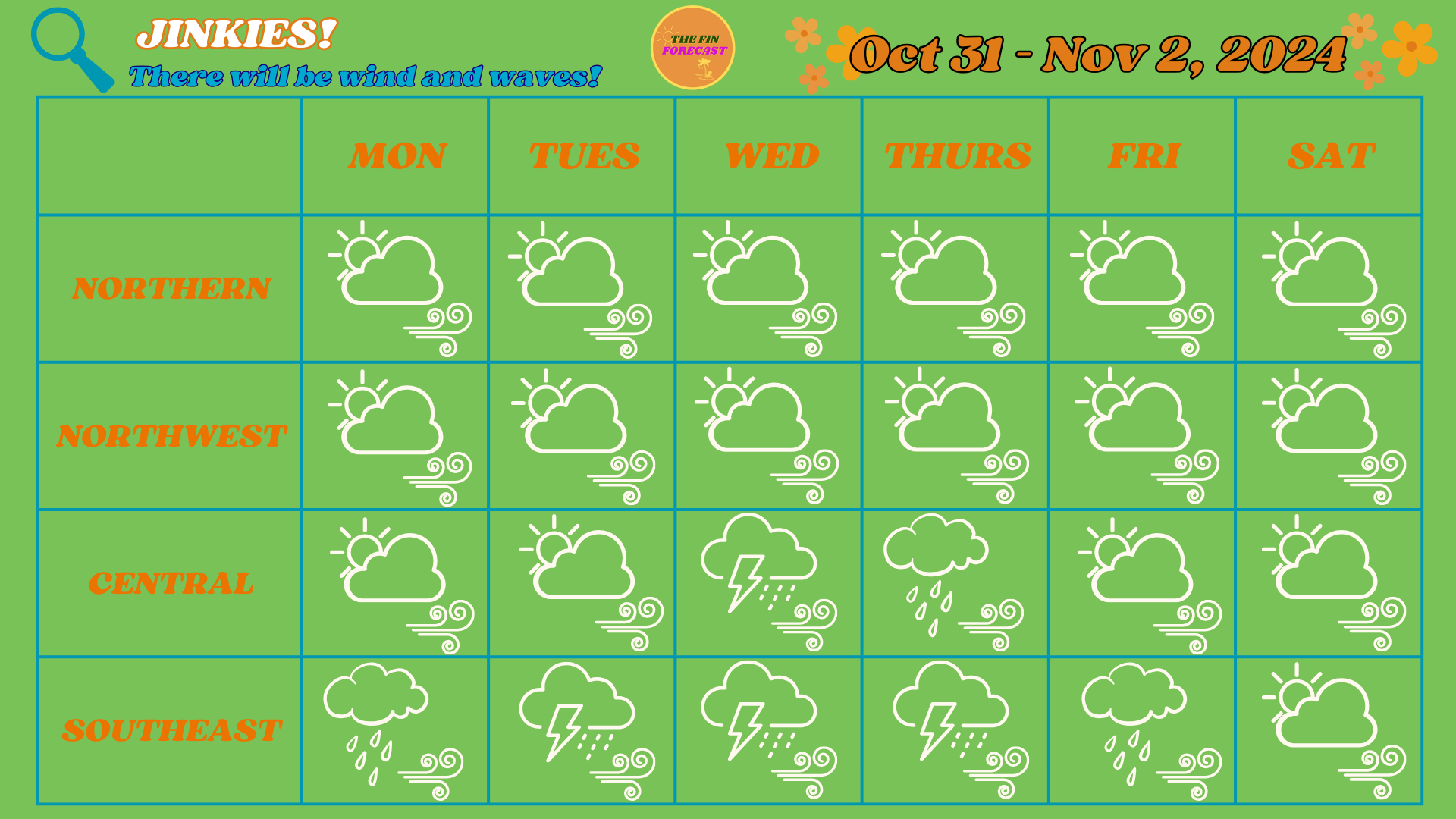
It will be quite a week with some wind and waves! Temperatures will drop and the southeast should expect more rainy conditions than other regions. Rain accumulation may range between 0.01 - 1.00 inches by next week Sunday for the Northern Region. In the Northwest, they may range between 0.25 - 1.00 inches. In Central, they may range between 0.40 - 1.25 inches and 0.75 - 2.50 inches in the Southeast. These are high estimates, but they may not fully capture the amount of rain so note that flooding is very possible in low-lying areas and possible flash flooding in the central and southeast regions! This is also a reminder that you can see rain accumulation total here for multiple islands, thanks to the CoCoRAHS network!
To get an idea of how hot or cool it may feel, add the heat index number to the high and low temperatures in these forecasts. Please watch out for Heat Advisories from the Bahamas Department of Meteorology!
The Blog:
On Monday, there may be cloudy conditions with showers everywhere, especially in the southeast. Thunderstorms are possible in the northern region and possible in the southeast. Northeasterly and easterly winds will be mostly breezy and a little calm everywhere. Temperatures will range with highs near 80 - 82°F and lows near 76 - 77°F in the northern region (Heat index +4°F), highs near 83 - 84°F and lows near 75 - 77°F in the northwest (Heat index +5°F), highs near 83°F and lows near 78 - 79°F in the central region (Heat index +5°F), and highs between 85 - 86°F and lows near 80°F in the southeast (Heat index +9°F to +10°F). Watch for sea swells all around The Bahamas, especially around the southeast.
On Tuesday, cloudy conditions with showers are expected, especially in the southeast. Thunderstorms are likely everywhere, especially in the northwest and central regions. Northeasterly and easterly winds will be breezy and strong (20 - 25 kts) in the northern and northwest and strong in the central and southeast regions. Temperatures will range with highs near 82°F and lows near 76 - 77°F in the northern region (Heat index +5°F), highs near 84°F and lows near 75 - 76°F in the northwest (Heat index +5°F), highs near 83 - 84°F and lows near 77°F in the central region (Heat index +6°F), and highs between 84 - 85°F and lows near 78°F in the southeast (Heat index +8°F to +12°F). Watch for sea swells and waves around The Bahamas.
On Wednesday, expect cloudy conditions with showers and rain. Rainfall should be light to moderate in the northern and northwest, moderate to heavy in the central region, and heavy in the southeast. Thunderstorms are possible in the central region and likely in the southeast. Easterly winds will be strong and breezy with gusts in the northern region. Northeasterly and easterly winds will be breezy and strong in the northwest and strong with gusts in the central and southeast regions. Temperatures will range with highs near 81 - 82°F and lows near 74 - 76°F in the northern region (Heat index +4°F to +5°F), highs near 82 - 84°F and lows near 74 - 75°F in the northwest (Heat index +6°F), highs near 82°F and lows near 77°F in the central region (Heat index +6°F), and highs between 83 - 84°F and lows near 77 - 78°F in the southeast (Heat index +7°F to +8°F). Watch for sea swells and waves around The Bahamas, especially around the northwest and central regions.

On Thursday, expect cloudy conditions with rain all over the country. Rainfall will be light in the northern region, light to moderate in the northwest, more moderate in the central region and moderate to heavy in the southeast. Thunderstorms are possible in the southeast. Northeasterly and easterly winds will be strong and breezy in all regions. Temperatures will range with highs near 80 - 81°F and lows near 75 - 76°F in the northern region (Heat index +4°F to +5°F), highs near 82 - 84°F and lows near 75 - 76°F in the northwest (Heat index +5°F), highs near 82°F and lows near 78°F in the central region (Heat index +5°F), and highs between 84 - 85°F and lows near 78 - 79°F in the southeast (Heat index +6°F to +7°F). Watch for sea swells around the Bahamas and waves around the central and southeast regions.
On Friday, expect cloudy conditions with showers and rain everywhere. Rainfall will be light to moderate in the northern, northwest and central regions and moderate to heavy in the southeast. Thunderstorms are possible in the southeast. Northeasterly and easterly winds will be breezy in the northern and northwest, breezy with gusts in the central region, and strong in the southeast. Temperatures will range with highs near 81 - 82°F and lows near 75 - 77°F in the northern region (Heat index +5°F to +6°F), highs near 83 - 85°F and lows near 75 - 76°F in the northwest (Heat index +5°F to +6°F), highs near 83°F and lows near 78°F in the central region (Heat index +6°F), and highs between 83 - 85°F and lows near 79°F in the southeast (Heat index +8°F). Watch for sea swells everywhere and waves in the southeast.
On Saturday, expect cloudy conditions with possible showers. Rainfall will range from light to moderate throughout the country. Northeasterly and easterly winds will be calm and breezy in the northern and northwest regions, breezy and strong in the central region and strong with gusts in the southeast. Temperatures will range with highs near 81 - 82°F and lows near 75 - 77°F in the northern region (Heat index +5°F to +6°F), highs near 83 - 85°F and lows near 75 - 77°F in the northwest (Heat index +6°F), highs near 83°F and lows near 78°F in the central region (Heat index +6°F), and highs between 84 - 86°F and lows near 79°F in the southeast (Heat index +8°F). Watch for sea swells all over The Bahamas and waves in the central and southeast regions. The waves may be big in the southeast so be on the lookout!

Hurricane News
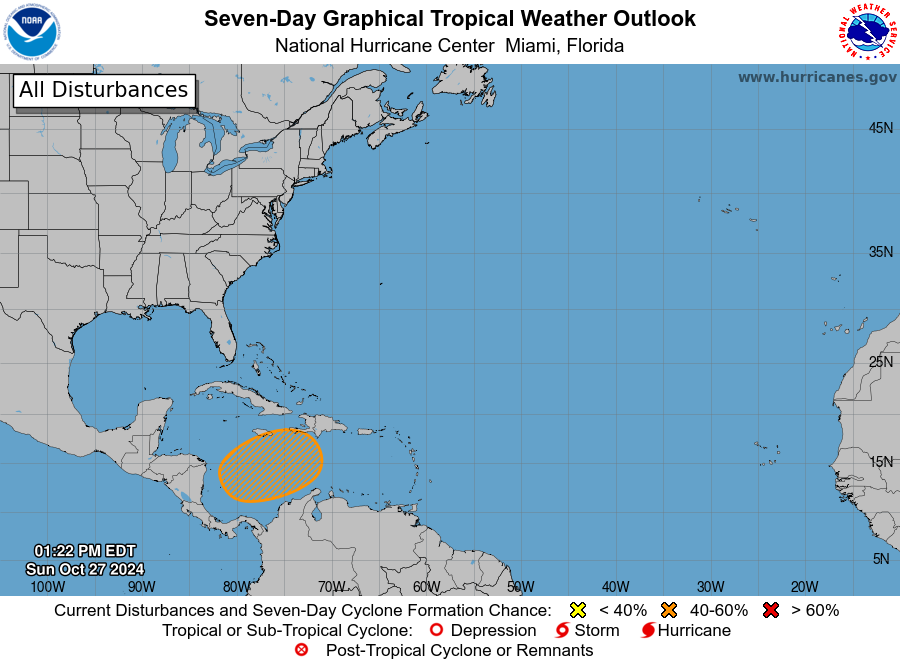
The next name in the 2024 Atlantic Hurricane Season list is Patty, which may form this system above South America, in the southwest Caribbean Sea. It currently has a 40% chance of formation in the next 7 days, while there is a 0% chance that anything will form in the next 48 hours. We have better information on the system’s formation into a storm by Wednesday or Thursday, but I would strongly advise that Bahamians prepare from a tropical cyclone that may make landfall next week (the first full week of November). This is a precautionary warning, not a prediction.
We remain on La Niña Watch, with a 60% chance of occurrence in the next 5 weeks.
ANNOUNCEMENTS & RESOURCES
These forecasts are subject to change throughout the week.
Featured on the archive blog → NEW PAGE TO SUPPORT GFMs!
The Fin Forecast 2024 Hurricane Predictions are out now! Click here to get them!
Also, keep up with Mr Weatherman on YouTube for more of a day-by-day report!
TELL US HOW WE ARE DOING! HOW WAS LAST WEEK'S FORECAST?!
Follow the Bahamas Department of Meteorology on Facebook to keep up with the weather and to follow thunderstorm warnings and watches. You can also find information on tides here.
Remember to have your hurricane plan ready! For more information on this, check out the Masters of Disasters' article on how to prepare a hurricane kit! They also have tips on how to survive the heat and how to prepare for a flood! The Colorado State University updated hurricane forecast can be found here. You can keep up with tropical cyclone formation updates here.
While you’re here, why not enjoy the Fin Forecast playlist on Spotify?