
Sometimes You Gotta Pop Out With Raincoats!
This week's forecast for The Bahamas for September 8 - 14.

This newsletter is brought to you by Marjahn Finlayson.
Super Bowl announcements and hurricane reports this Sunday.

Birthday Shoutouts
Happy Birthday to Breeah Rolle and Melissa Smith!

Special Sky Report!
The first quarter moon will be on Wednesday at 2:06 a.m. Look out for upcoming events! The Super Full Moon will be on the 17th along with a partial lunar eclipse on that same night! The autumn equinox will be on September 22nd at 8:43 a.m.
This week, the sun will set between 7:13 and 7:20 p.m. and rise between 6:53 and 6:55 a.m. Saturn and Jupiter will have perfect visibility in the sky this week, while Venus, Mars and Uranus will also be easy to see! Neptune and Mercury will be hard to see.
See what astronomers are saying here and what's visible in The Bahamas here.

The first quarter moon will fall in Sagittarius, which means that you can handle the obstacles that come your way with the right attitude. Bring it on! We are still in detail-focused and practical Virgo Season. Mercury will be being confident and grand-planning Leo until Monday when it will go back to Virgo, where the planet feels right at home. Mercury in Virgo calls for taking in useful information and expressing facts, which may come across as harsh sometimes. Venus in Libra is a time for cooperation and harmony while keeping equality and politeness in the air. Mars in Cancer means we may be indirect with approaching goals but super defensive of our loved ones and taking action toward our own peace and comfort!
What do the astrology people say about ALL this?
Let's get into this week's forecast!
Current Conditions:
The radar and satellite show slight rainy activity around North Andros, but the satellite is showing clear-ish skies.
Tonight
There may be cloudy conditions with showers everywhere! Thunderstorms are possible in the northern and northwest regions. Southeasterly winds will be light (5 - 10 kts) in the northern region, southeasterly and easterly winds will be calm (10 - 15 kts) in the northwest and central regions, and easterly winds will be breezy (15 - 20 kts) in the southeast. Temperature lows will be near 81 - 83°F in the northern region, 80 - 82°F in the northwest, 82°F in the central region and 81°F in the southeast. Watch for sea swells in the southeast.
The Week Ahead:
Quick Summary:
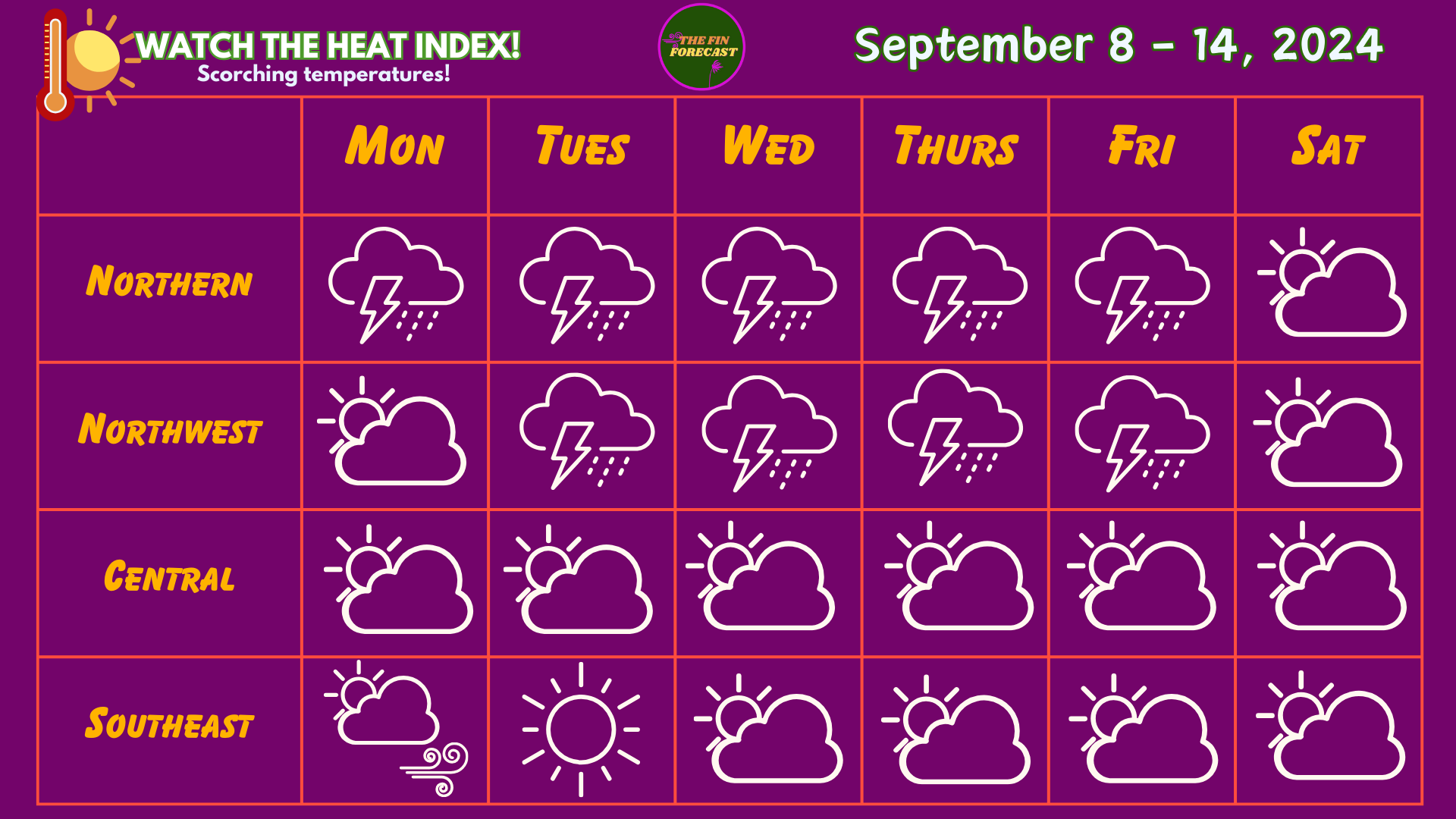
There will be some thunder and lightning in The Bahamas this week, so pop out with raincoats and boots! We are looking at less rain, but also scorching heat with humidity! There will also be less Saharan Air Layer dust (little to none). To get an idea of how hot or cool it may feel, add the heat index number to the high and low temperatures in these forecasts. Please watch out for Heat Advisories from the Bahamas Department of Meteorology!
Rain accumulation may range between 0.50 - 2.50 inches by next week Sunday for the Northern Region. In the Northwest, they may range 0.20 - 2.00 inches. In Central, they may range between 0.15 - 0.50 inches and 0.20 - 1.00 inches in the Southeast. These estimates may not fully capture the amount of rain so note that flooding is very possible in low-lying areas! This is also a reminder that you can see rain accumulation total here for multiple islands, thanks to the CoCoRAHS network!
The Blog:
On Monday, expect cloudy conditions with a chance of showers everywhere, especially in the northern and southeast regions. Rainfall will be moderate in the northern region and light to moderate in the northwest, central and southeast regions. Thundershowers are very likely in the northern region and possible to occur in the northwest and central regions. Light southerly and southeasterly winds in the northern region will become more easterly and weaker. Southerly and easterly winds will be light and calm in the northwest and calm in the central region, while easterly winds will be calm and breezy in the southeast. IT WILL BE SCORCHING HOT! Temperatures will range with highs near 87 - 88°F and lows near 81 - 83°F in the northern region (Heat index +13°F to +14°F), highs near 90 - 93°F and lows near 79 - 81°F in the northwest (Heat index +14°F to +15°F), highs near 87 - 88°F and lows near 81°F in the central region (Heat index +14°F), and highs between 86 - 89°F and lows near 81°F in the southeast (Heat index +13°F to +16°F). Watch for sea swells in the southeast.
On Tuesday, expect cloudy conditions with showers throughout The Bahamas, especially in the northern and northwest regions. Rainfall should be moderate to heavy in the northern region, moderate in the northwest, and light to moderate in the central and southeast regions. Thundershowers are very likely in the northern region, likely in the northwest and central regions, and possible in the southeast. Southeasterly and easterly winds will be light and calm in the northern region, and calm in the northwest and central regions. Easterly winds will be calm with gusts in the southeast. ANOTHER HOT DAY! Temperatures will range with highs near 87°F and lows near 80 - 83°F in the northern region (Heat index +12°F to +13°F), highs near 90 - 93°F and lows near 79 - 81°F in the northwest (Heat index +13°F to +14°F), highs near 87 - 88°F and lows near 81°F in the central region (Heat index +12°F), and highs between 86 - 89°F and lows near 80°F in the southeast (Heat index +12°F to +13°F).
On Wednesday, expect cloudy conditions with showers everywhere, especially in the northern and northwest regions. Rainfall should be heavy in the northern region, moderate to heavy in the northwest, and light in the central and southeast regions. Thunderstorms are very likely in the northern and northwest regions, and likely in the central and southeast regions if there are storms. Easterly winds will be weak (0 - 5 kts) and light in the northern and northwest regions, light and calm in the central region, and calm in the southeast. Another HOT day, but it will cool down a little! Temperatures will range with highs near 86 - 87°F and lows near 80 - 82°F in the northern region (Heat index +11°F), highs near 88 - 92°F and lows near 79 - 81°F in the northwest (Heat index +11°F to +12°F), highs near 86 - 87°F and lows near 81°F in the central region (Heat index +11°F), and highs between 85 - 87°F and lows near 80°F in the southeast (Heat index +11°F to +13°F).

On Thursday, look out for cloudy conditions with showers everywhere, especially in the northern and northwest regions. Rainfall will be moderate to heavy in the northern region, moderate in the northwest, and light in the central and southeast regions. Thunderstorms are very likely in the northern and northwest regions and likely in the central and southeast regions if it rains in those areas. Easterly and southeasterly winds will be weak and light in the northern and northwest regions, and easterly winds will be light and calm in the central and southeast regions. Temperatures will range with highs near 87°F and lows near 81 - 83°F in the northern region (Heat index +11°F), highs near 88 - 91°F and lows near 79 - 81°F in the northwest (Heat index +11°F to +12°F), highs near 86 - 87°F and lows near 81°F in the central region (Heat index +11°F), and highs between 85 - 87°F and lows near 80 - 81°F in the southeast (Heat index +12°F to +13°F).
On Friday, expect some cloudy conditions with showers everywhere. Rainfall will be moderate in the northern and northwest regions, and light in the central and southeast regions. Thunderstorms are likely in the northern and northwest regions and very possible in the central and southeast regions if it rains in these areas. Weak winds will come from varying directions in the northern region. Mostly southeasterly and variable winds will be weak and light in the northwest. Mostly easterly and variable winds will be weak and light in the central region. Easterly winds will be light in the southeast. Temperatures will range with highs near 86 - 87°F and lows near 81 - 83°F in the northern region (Heat index +11°F to +12°F), highs near 88 - 90°F and lows near 79 - 81°F in the northwest (Heat index +12°F to +13°F), highs near 86 - 87°F and lows near 81°F in the central region (Heat index +11°F), and highs between 86 - 87°F and lows near 81°F in the southeast (Heat index +12°F to +14°F).
On Saturday, expect cloudy conditions with light to moderate showers all over the country, especially in the northern region. Thunderstorms are very likely in the northern region and likely everywhere else. Expect it to be humid! Weak and light winds will come from varying directions in the northern region. Mostly easterly and variable winds will be light in the northwest, and light and calm in the central and southeast regions. Temperatures will range with highs near 86 - 87°F and lows near 80 - 82°F in the northern region (Heat index +11°F), highs near 88 - 91°F and lows near 78 - 80°F in the northwest (Heat index +11°F to +12°F), highs near 86 - 87°F and lows near 80°F in the central region (Heat index +12°F), and highs between 86 - 88°F and lows near 81°F in the southeast (Heat index +13°F to +14°F).

Hurricane News
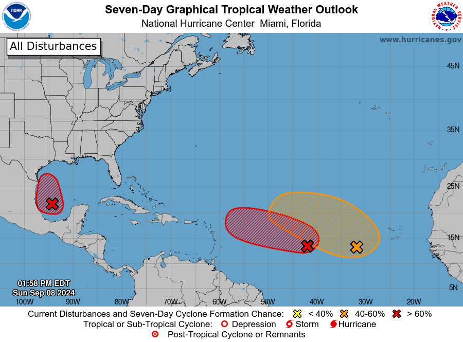
There are currently THREE systems in the Atlantic Ocean.
AL91 in the Gulf of Mexico currently has a 90% chance of formation in the next 48 hours and 7 days. It is expected to track toward and make landfall in the United States.
AL92 in the Central Tropical Atlantic has a 60% chance of formation in the next 48 hours and a 70% of formation in the next 7 days. The track is uncertain now but it is expected to move toward the Lesser Antilles in the next few days.
A disturbance in the Eastern and Central Tropical Atlantic has a 0% chance of formation in the next 48 hours and a 50% chance of formation in the next seven days.
The next names for the Hurricane Season are Francine, Gordon and Helene.
We remain in the ENSO Neutral period, but we are officially in La Niña watch. We expect a 66% chance of the La Niña occurring between September to November.
There is some buzz about Atlantic Ocean waters cooling due to a possible Atlantic La Niña event, which could impact the Pacific La Niña’s formation later this autumn. It is something to keep an eye on, but it does not mean the sea surface temperatures in the Atlantic are suddenly getting cooler. Ocean heat content and sea surface temperatures are still very high in the Gulf of Mexico, the Caribbean Sea and some of The Bahamas. This Atlantic La Niña event is a teleconnection that sometimes happens as are result of atmospheric physical reasons. Scientists are confused about what is triggering it right now and why it’s occurring at this moment, instead of during an El Niño year in the Pacific Ocean (which would be normal).
ANNOUNCEMENTS & RESOURCES
These forecasts are subject to change throughout the week.
Featured on the archive blog → NEW PAGE TO SUPPORT GFMs!
The Fin Forecast 2024 Hurricane Predictions are out now! Click here to get them!
Also, keep up with Mr Weatherman on YouTube for more of a day-by-day report!
TELL US HOW WE ARE DOING! HOW WAS LAST WEEK'S FORECAST?!
Follow the Bahamas Department of Meteorology on Facebook to keep up with the weather and to follow thunderstorm warnings and watches. You can also find information on tides here.
Remember to have your hurricane plan ready! For more information on this, check out the Masters of Disasters' article on how to prepare a hurricane kit! They also have tips on how to survive the heat and how to prepare for a flood! The Colorado State University updated hurricane forecast can be found here. You can keep up with tropical cyclone formation updates here.