
Batten Down the Hatches for the Rainstorms of The Caribbean!
This week's forecast for The Bahamas for June 7 - 13.

This newsletter is brought to you by Marjahn Finlayson.
Do you want some free Fin Forecast merch?! Answer this question to win!
Birthday Shoutouts
Happy Birthday to Tanicia Pratt, Taylor Hoffman, Nicholas Fox, and Drexel Woods!

Do you want a birthday shoutout? Click here to fill out a quick form.
Special Sky Report!
The last quarter moon will take place on Monday at 6:03 a.m. The sun will set between 7:57 and 7:59 p.m. and rise between 6:18 and 6:19 a.m. Venus, Jupiter, Mars and Saturn will be visible in the sky this week, while Uranus, Neptune and Mercury will be difficult to see.
See what the astronomers are saying here. See what’s visible in the Bahamas here.
Recall that the spring tide, when the tide is the highest or the lowest of the month, occurs twice a month during full and new moons. See the Bahamian tide chart for 2026 here.
Note that the Summer Solstice is on June 21st at 4:24 a.m.

The last quarter moon will fall in Pisces which can indicate a reflective period for us. Gemini Season wants us to be knowledgeable, social and optimistic, but we may run into issues with being too rational. Mercury in Cancer needs a deeper understanding of information, especially about everyone around us and the broader world. Venus will move from Cancer to Leo on Saturday, which means that nurturing, protective and devoted love will start to feel more grand and warm-hearted! It’s all about adoration and wanting to go out with people! Mars in Taurus challenges us to stay the course and to be persistent. We may be stubborn and defensive, but patience is a virtue!
Here are some updates on the outer planets: Jupiter will start moving out of Cancer on June 9th, Saturn is in Aries, Uranus is in Gemini, Neptune is in Aries and Pluto is retrograding in Aquarius. For more on what this means, see what the astrology people have to say about this.
Let's get into this week's forecast!
The Week Ahead:
Quick Summary:
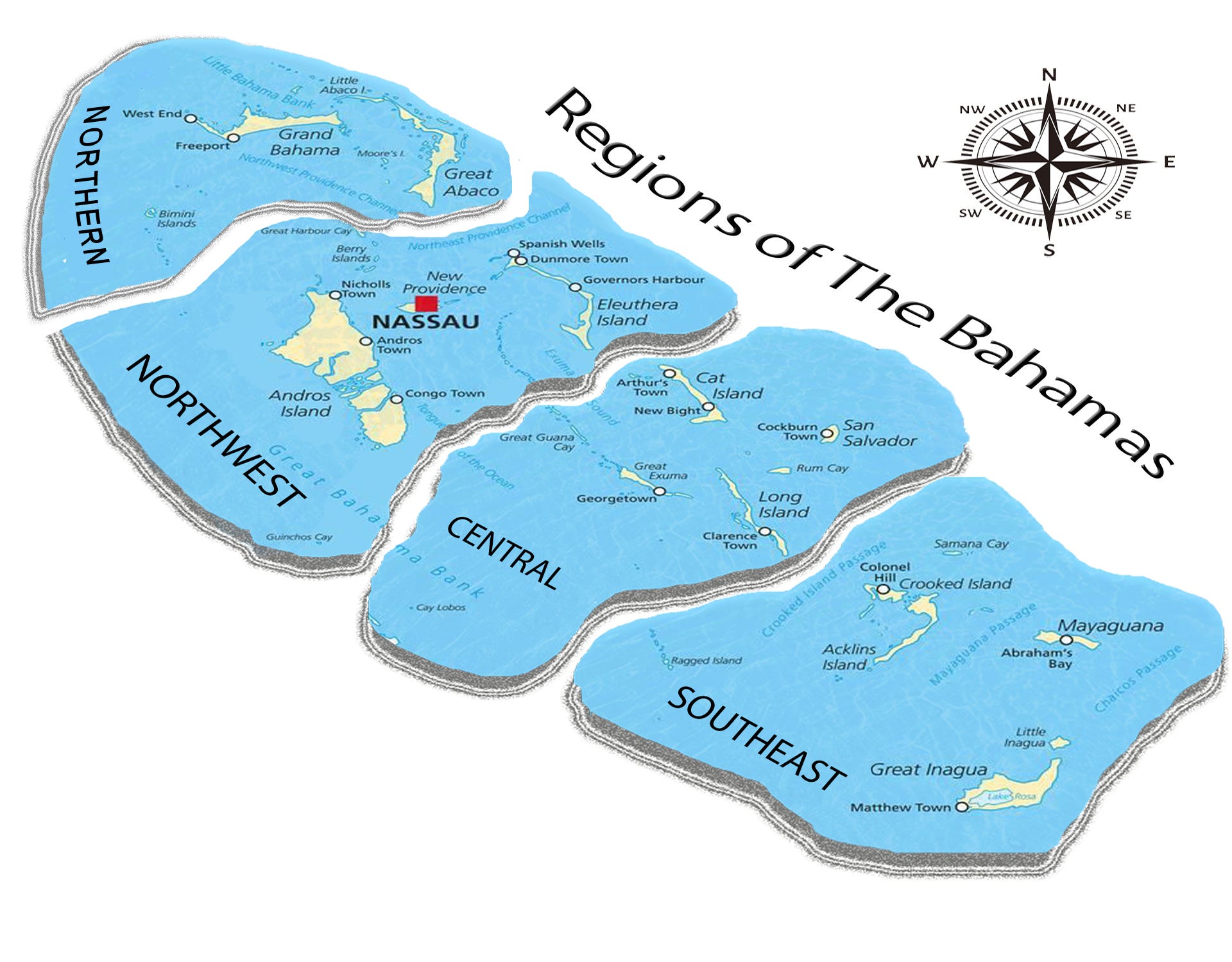
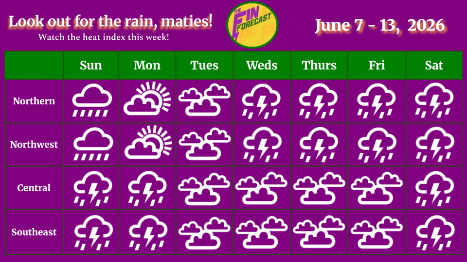
Shiver me timbers! With rain with this, you’d think that Davy Jones was making a comeback! Expect lots of thunderstorms and rain this week all over the country! Rain accumulation may range between 0.05 - 3.00 inches by next Sunday in the northern region. In the northwest, they may range between 0.40 - 2.50 inches. In the central region, they may range between 0.40 - 2.00 inches and 0.50 - 2.50 inches in the southeast. Flooding will very likely occur in low-lying areas! This is also a reminder that you can see total rain accumulation here for multiple islands, thanks to the CoCoRAHS network!
A SUPER El Niño is coming this summer!1 The rain may bring a little relief, but it is another HOT week! Keep your eye on the heat index! To get an idea of how cool it may feel, add the heat index number to the high and low temperatures in these forecasts.
The Blog:
On Sunday, frontal activity may impact the weather. Expect rainy conditions with clouds everywhere, especially in the central and southeast regions. Rainfall will be light to moderate in the northern and northwest regions, moderate to heavy in the central region, and heavy in the southeast. Thunderstorms are possible in the northern and northwest, but likely to occur in the central and southeast regions. Southeasterly and easterly winds will be mostly calm (10 - 15 kts) in the northern and northwest regions. Mostly southeasterly winds will be light (5 - 10 kts) and calm in the central region. Southeasterly and easterly winds will go from calm and breezy (15 - 20 kts) to light and calm in the southeast. Temperatures will range with highs near 83 - 85°F and lows near 78 - 80°F in the northern region (Heat index +6°F to +8°F), highs near 85 - 88°F and lows near 75 - 77°F in the northwest (Heat index +6°F to +9°F), highs near 82 - 83°F and lows near 77 - 78°F in the central region (Heat index +6°F to +8°F), and highs between 84 - 85°F and lows near 79 - 80°F in the southeast (Heat index +7°F to +10°F).
On Monday, a trough over the northwest may impact weather. Expect cloudy conditions with showers everywhere, especially in the northwest, central and southeast regions. Rainfall will be light to moderate in the northern, northwest and central regions, and moderate to heavy in the southeast. Thunderstorms are possible in the northern and northwest regions, likely to occur in the central region and very likely to occur in the southeast. Mostly easterly winds will be light in the northern region. Calm southeasterly and easterly winds will become light and calm northeasterly and easterly winds in the northwest. Mostly southeasterly winds will be weak (0 - 5 kts) and light in the central region. Mostly southeasterly winds will be light and calm in the southeast. Temperatures will range with highs near 84 - 85°F and lows near 78 - 80°F in the northern region (Heat index +6°F to +8°F), highs near 85 - 88°F and lows near 76 - 78°F in the northwest (Heat index +7°F to +10°F), highs near 83 - 84°F and lows near 77 - 78°F in the central region (Heat index +7°F to +9°F), and highs between 85 - 86°F and lows near 79 - 80°F in the southeast (Heat index +9°F to +12°F).
On Tuesday, expect mostly cloudy conditions with light to moderate showers everywhere, especially in the northern and northwest regions. Thunderstorms are likely to occur in the northern and northwest regions, and very likely to occur in the central and southeast regions. Weak and light southeasterly and easterly winds will become light and calm northeasterly and easterly winds in the northern and northwest regions. Weak and light southeasterly and easterly winds will become light northerly and easterly winds in the central region. Light and calm southeasterly and easterly winds may become light northeasterly and easterly winds in the southeast. Temperatures will range with highs near 84 - 85°F and lows near 78 - 80°F in the northern region (Heat index +6°F to +8°F), highs near 85 - 88°F and lows near 76 - 78°F in the northwest (Heat index +7°F to +10°F), highs near 83 - 84°F and lows near 77 - 78°F in the central region (Heat index +7°F to +8°F), and highs between 84 - 86°F and lows near 79°F in the southeast (Heat index +8°F to +11°F).
On Wednesday, expect mostly cloudy conditions with light to moderate showers everywhere, especially in the northern and northwest regions. Thunderstorms are likely to occur everywhere. Southeasterly and easterly winds will be light and calm in the northern and northwest regions. Mostly southeasterly and easterly winds will be light and calm in the central region. Southeasterly and easterly winds will be light and calm in the southeast. Temperatures will range with highs near 84°F and lows near 78 - 80°F in the northern region (Heat index +6°F to +8°F), highs near 85 - 88°F and lows near 76 - 77°F in the northwest (Heat index +6°F to +9°F), highs near 83 - 84°F and lows near 77 - 78°F in the central region (Heat index +6°F to +8°F), and highs between 84 - 86°F and lows near 79°F in the southeast (Heat index +7°F to +10°F).

On Thursday, expect cloudy conditions with moderate to heavy rain in the northern and northwest regions, and possible light showers in the central and southeast regions. Thunderstorms are very likely to occur everywhere. Southeasterly and easterly winds will be light and calm in the northern , northwest and central regions and calm and breezy in the southeast. Temperatures will range with highs near 84°F and lows near 78 - 79°F in the northern region (Heat index +6°F to +7°F), highs near 85 - 87°F and lows near 76 - 78°F in the northwest (Heat index +6°F to +9°F), highs near 83 - 84°F and lows near 78°F in the central region (Heat index +6°F to +8°F), and highs between 85 - 86°F and lows near 79°F in the southeast (Heat index +8°F to +11°F).
On Friday, expect cloudy conditions with moderate to heavy rain in the northern and northwest regions and possible light showers in the central and southeast regions. Thunderstorms are very likely to occur everywhere. Mostly southeasterly winds will be light with possible gusts in the northern region, and light and calm with gusts in the northwest. Southeasterly and easterly winds will be light and calm in the central region and calm and breezy in the southeast. Temperatures will range with highs near 84 - 85°F and lows near 79 - 80°F in the northern region (Heat index +6°F to +7°F), highs near 85 - 87°F and lows near 76 - 78°F in the northwest (Heat index +6°F to +9°F), highs near 84°F and lows near 78°F in the central region (Heat index +6°F to +8°F), and highs between 85 - 86°F and lows near 79 - 80°F in the southeast (Heat index +8°F to +12°F).
On Saturday, expect cloudy conditions with moderate to heavy rainfall everywhere. Thunderstorms are very likely to occur everywhere. Southerly and southeasterly winds will be calm and breezy with gusts in the northern and northwest regions, and calm with gusts in the central region. Southeasterly and easterly winds will be calm and breezy in the southeast. Temperatures will range with highs near 84 - 85°F and lows near 79 - 80°F in the northern region (Heat index +7°F to +8°F), highs near 85 - 87°F and lows near 76 - 79°F in the northwest (Heat index +6°F to +9°F), highs near 84°F and lows near 78 - 79°F in the central region (Heat index +7°F to +9°F), and highs between 85 - 87°F and lows near 80°F in the southeast (Heat index +8°F to +12°F). Watch for possible sea swells around the northern region.

Hurricane News
Welcome to the 2026 Hurricane Season! NOAA is predicting a below-normal Hurricane Season. No hurricanes are expected in the next 7 days. Watch out for the Saharan dust this week though!

See more information on the Fin Forum here.
ANNOUNCEMENTS & RESOURCES
These forecasts are subject to change throughout the week.
WIN FIN FORECAST MERCH! Answer this question to win a Fin Forecast item!
MORE NEWS! The next Fin Forum guest is Bahamian Naturalist, Scott Johnson! Tune in a few weeks!

Follow the Bahamas Department of Meteorology on Facebook to keep up with the weather and to follow thunderstorm warnings and watches.
Check out our new website: www.finforecastweather.com!
Follow our social media on Facebook, LinkedIn and Instagram!
Also, keep up with Mr Weatherman on YouTube for more of a day-by-day report!
LET US KNOW HOW WE ARE DOING! HOW WAS LAST WEEK'S FORECAST?!
Remember to have your hurricane plan ready! For more information on this, check out the Masters of Disasters' article on how to prepare a hurricane kit! They also have tips on how to survive the heat and how to prepare for a flood! The Colorado State University updated hurricane forecast can be found here. You can keep up with tropical cyclone formation updates here.
The Fin Forecast is free. If you would like to send a gift to us, click here!
Check the Fin Forum on more on this later this week!