

This newsletter is brought to you by Marjahn Finlayson.

Hurricane News
Of course… a little bit about Humberto too…
Current conditions: Potential Tropical Storm Nine, soon to be Imelda, is currently hover over the southeast Bahamas, Turks and portions of Cuba as disturbance with maximum sustained winds are near 35 mph (55 km/h) with higher gusts. It is expected to become a tropical depression by Saturday and a tropical storm by Saturday night or early Sunday morning. It has 90% chance of forming in 48 hours and 7 days.
A Tropical Storm Warning (tropical storm conditions are expected within 36 hours) is effect for the Central Bahamas.
A Tropical Storm Watch (tropical storm conditions are expected within 48 hours) is in effect for the northwest and northern regions of The Bahamas. Notably for Eleuthera, New Providence, the Abaco Islands, the Berry Islands and Grand Bahama.
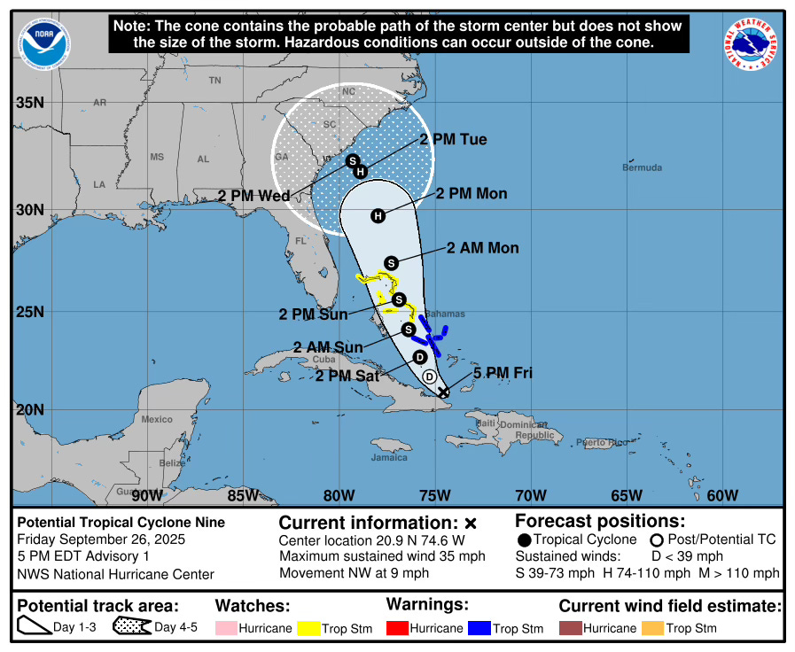
The image above shows a cone of probability for the path the centre of the storm is most likely to take. This is important because the strongest winds of a tropical cyclone are normally around the centre or eye, while the strongest winds are in the eyewall. Recall that though the cone gives us an idea of where the centre of Imelda will be, it does NOT show the size of the storm and give a big idea of the effects of the storm.
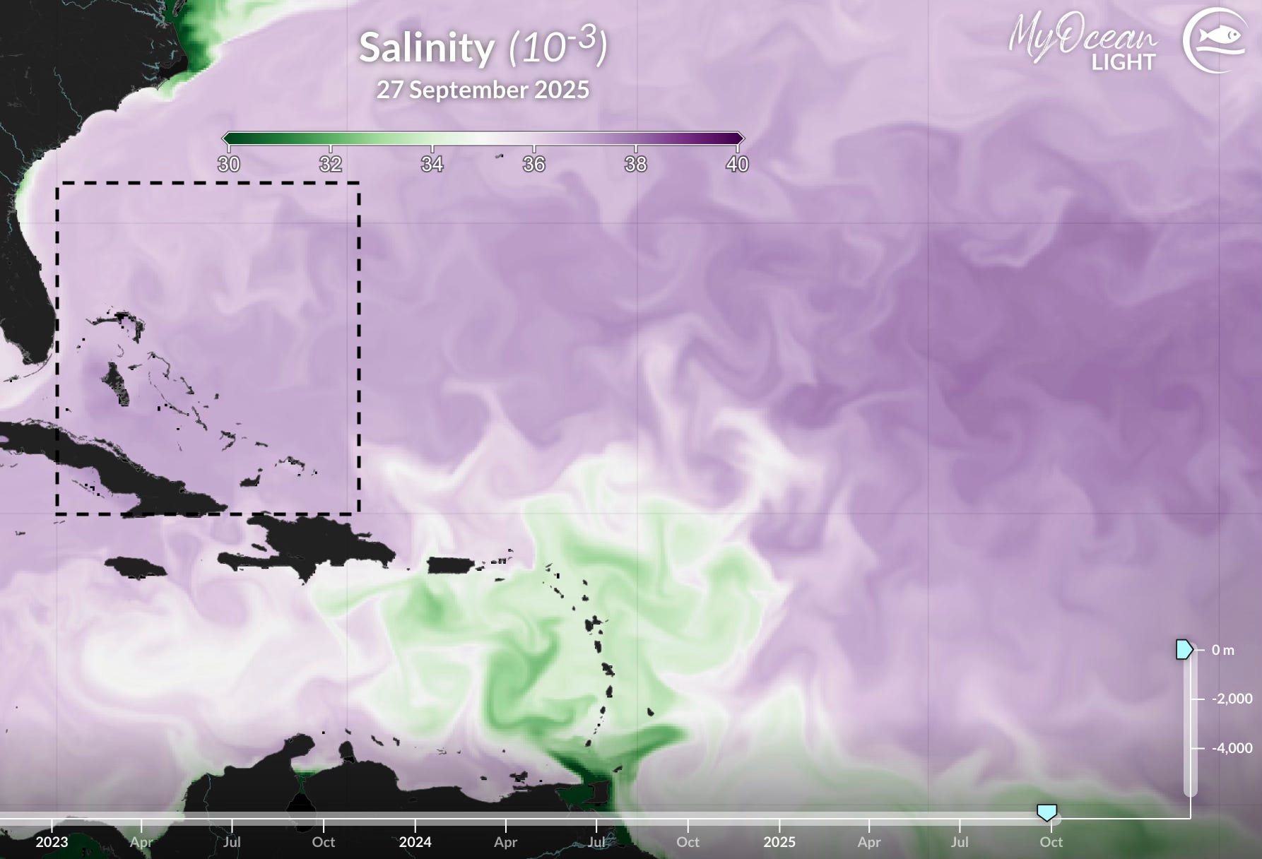
Rapid Intensification: Slightly increased vertical wind shear, a sustained warm ocean (increased ocean heat content and high sea surface temperatures (aka SST)) and high sea surface salinity (SSS; see image below) are impacting Soon to be Imelda’s slow intensification. Despite SST being above 26ºC, the SSS is higher than 35 PSU so it is harder for the storm to rapidly intensify.
Additionally, at this moment, models do not predict this storm becoming higher than a Category 1 hurricane if it becomes a hurricane. However, for The Bahamas, Imelda will mostly remain a tropical storm.
Storm Track: The Bahamas is directly in Soon To Be Imelda’s direct path.
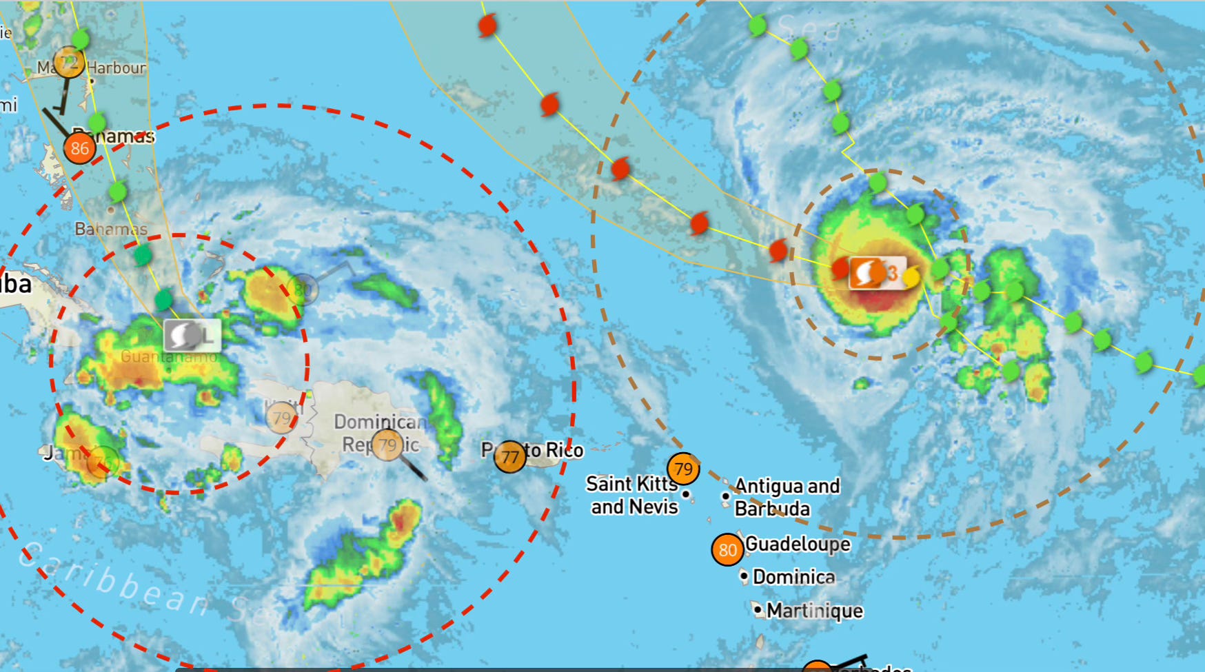
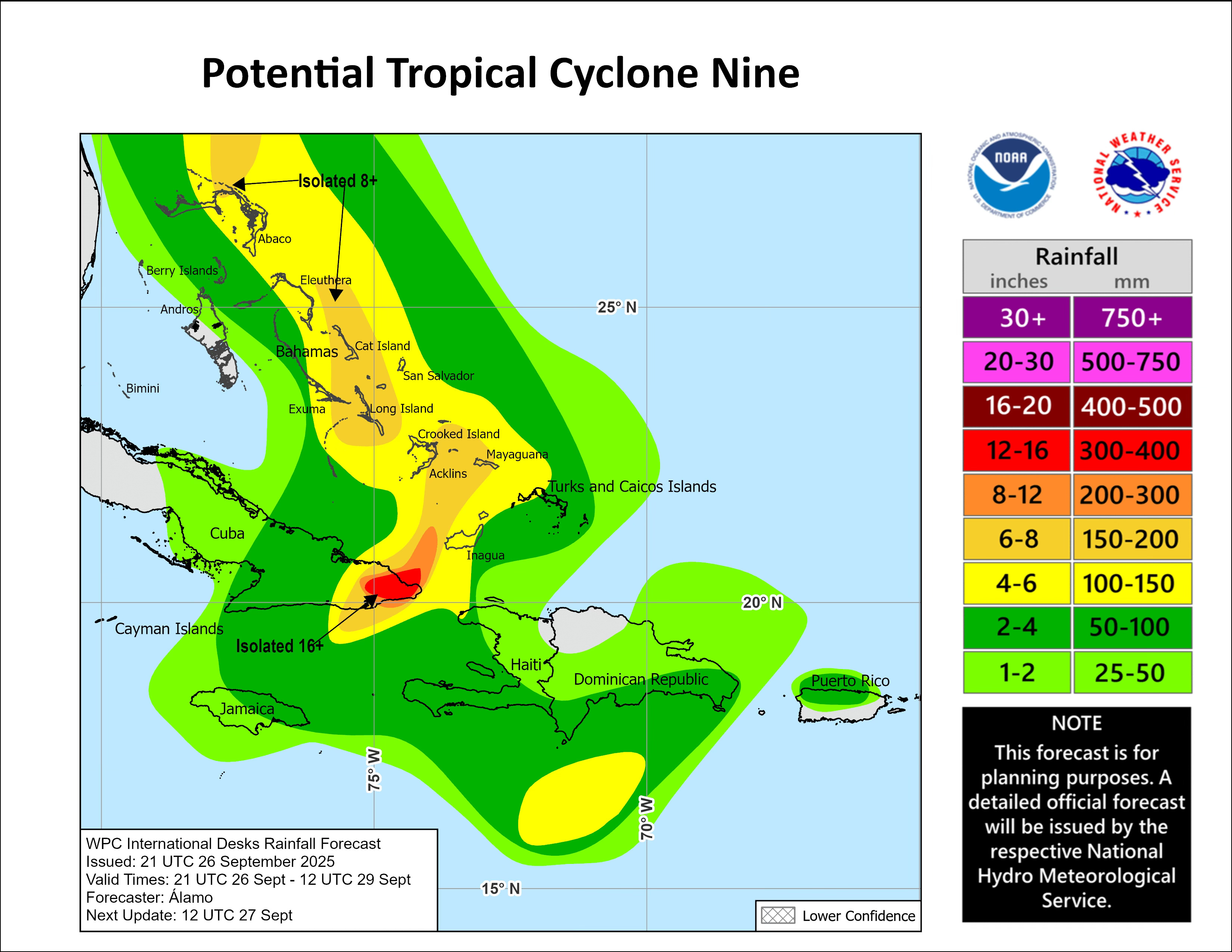
Storm Size: The image below shows the satellite image of Soon To Be Tropical Storm Imelda and Hurricane Humberto (which is East of Imelda), captured on 09/26/2025 at 06:58:32 P.M. EST. Imelda is currently still trying to organize itself to become a tropical depression over the Caribbean and near the southeast Bahamas. It is moving northwestward at 9 mph (15 km/h). The probable outer bands of the Soon To Be Imelda will likely impact all parts of The Bahamas, this weekend. More information on the outer bands and radius of this storm will be released later tonight or early tomorrow morning.
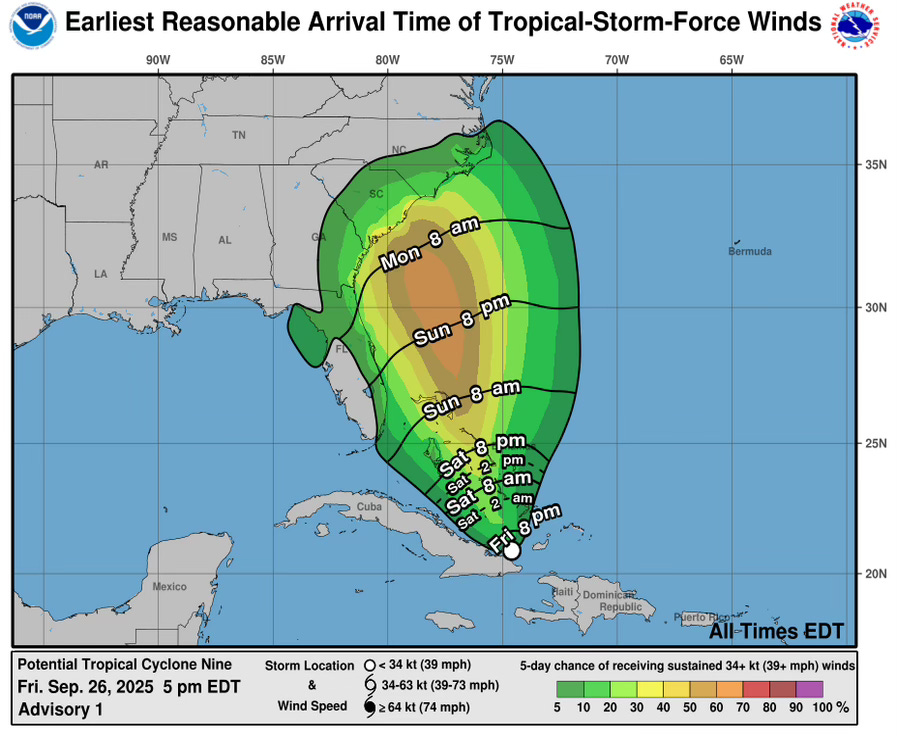
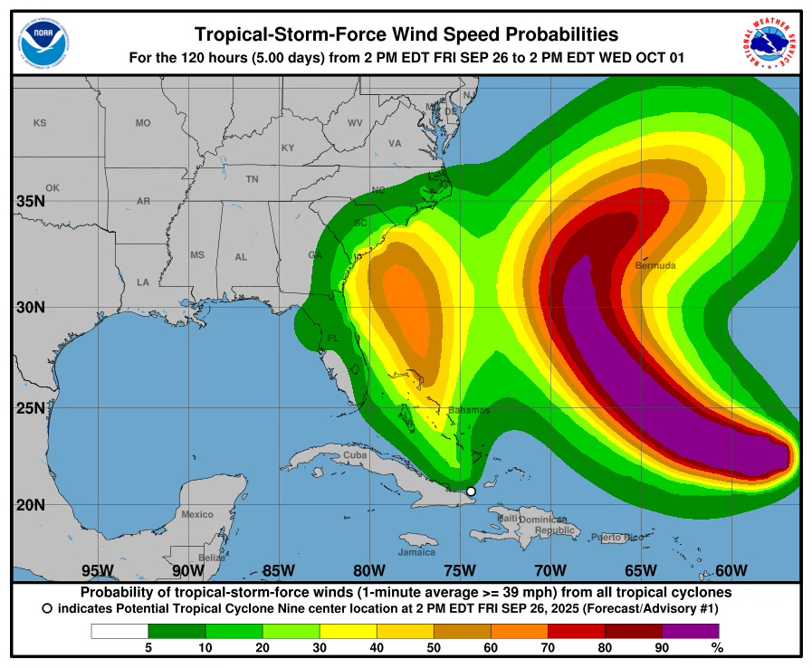
Storm Effects: The central, northwest and northern regions of The Bahamas will feel tropical-storm-force winds from tomorrow and into Sunday, successively. Please note the image below.
Imelda will produce heavy rainfall with thunderstorms throughout the weekend. Rainfall is expected to fall up to 8 inches in isolated regions! Flooding is very likely in low lying areas! Here’s a slight breakdown:
Northern Region: 2 - 8 inches
Northwest Region: 1 - 6 inches
Central Region: 2 - 8 inches
Southeast Region: 2 - 8 inches
Sea swells and waves are likely to cause life-threatening surf and rip current conditions this weekend and possibly into next week. Mariners and beach-goers should beware. Storm surge will also very likely occur with both Imelda and Humberto’s movements this weekend. (See the image below.)
Rest of the Season: September and October are still in the peak period of the Atlantic Ocean Hurricane Season, so more tropical cyclones will likely occur during this period. The Hurricane Season ends on November 30.
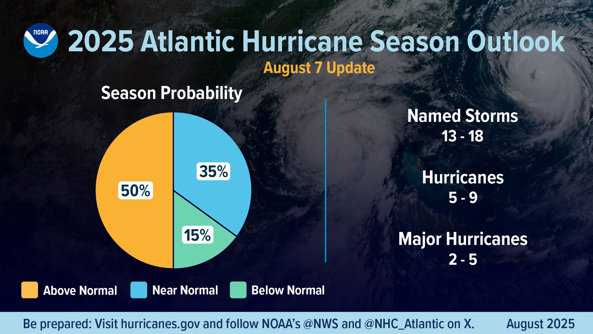
The NOAA 2025 Hurricane Season Outlook August 7 update shows this year continues to forecast an above normal hurricane season. As of this time, there have been 8 named storms in the Atlantic (soon to be 9). Three of these storms have become hurricanes (and also major hurricanes). In regard to the El Niño Southern Oscillation (ENSO) , we are currently La Niña Watch. A transition from ENSO-neutral to La Niña is likely in the next couple of months, with a 71% chance of La Niña during October - December 2025. This may impact tropical cyclone formation and behavior during October and November. (For more information on ENSO impacts, see the Fin Forecast 2025 Predictions for the Atlantic Hurricane Season: Concerns for The Bahamas.)
Hurricane Preparation: Now is a good time to start thinking about storm preparation and hurricane plans with friends and family. A good place to begin would be to check out the Masters of Disasters’ article on how to prepare a hurricane kit and to to follow the DRM Authority on Facebook. A list of hurricane shelters should also be available to double-check.
For your mental health’s sake, please do not follow a bunch of American Cable News Meteorologists for updates! Follow the Hurricane officials such as NOAA and keep up with Mr Weatherman on YouTube for Caribbean-focused reporting. Be sure to listen to authorities and keep up with local news.
ANNOUNCEMENTS & RESOURCES
These forecasts are subject to change throughout the week.
Follow the Bahamas Department of Meteorology on Facebook to keep up with the weather and to follow thunderstorm warnings and watches. You can also find information on tides here.
The Colorado State University updated hurricane forecast can be found here. You can keep up with tropical cyclone formation updates here.